HCOVG logo
  • Software Home
    • RodHome..
  • Premium software
    • GEOrient
    • GeoCalculator
    • Purchase
    • Installation, etc
  • GIS Tools
    • GeoQSymbol for QGIS
    • GeoMapSymbol for Mapinfo
    • GeoMapVector for Mapinfo
    • PolyNodeExtractor for Mapinfo
  • Other Software
    • Strain & Shear Calculator
    • Ghoshflow
    • GeoFryPlots
    • Teaching animations...
  • Contact me
Rod Holcombe logo
  • Software Home
    • RodHome..
  • Premium software
    • GEOrient
    • GeoCalculator
    • Purchase
    • Installation, etc
  • GIS Tools
    • GeoQSymbol for QGIS
    • GeoMapSymbol for Mapinfo
    • GeoMapVector for Mapinfo
    • PolyNodeExtractor for Mapinfo
  • Other Software
    • Strain & Shear Calculator
    • Ghoshflow
    • GeoFryPlots
    • Teaching animations...
  • Contact me

GeoQSymbol for QGIS

GeoQSymbol:   structural symbols for QGIS maps
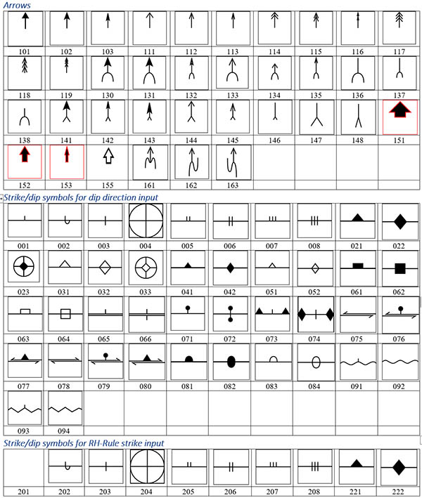
GeoQSymbol symbol set

GeoQSymbol©

is a set of SVG structural symbols for use in QGIS. They come with both dip direction and right-hand-rule strike convention orientations, allowing application of simple rotation rules.
Also include in the download is a Python function, which allows dip labels to be correctly positioned for any given orientation. This function is added to the expression builderin QGIS
Download...
Free [~730kb]
Disclaimers...

What it does
  • GeoQSymbol is simply a compilation of common structural symbols in SVG format. Although all of these symbols can be constructed within the QGIS style symbology, the collection provides shortcuts to this process. The stroke, fill, and size of all of the symbols can be changed.
    All of the strike-dip symbols are repeated in both dip-direction and right-hand-rule strike orientations. That is, the azimuth in a dip direction or strike attribute field can be used directly to rotate the symbol
  • The download includes a readme pdf that explains in detail how to load and use svg symbol files.
  • The download also includes a Python function that can be used to calculate the correct placement of dip labels depending on the orientation of the symbol. The function calculates the angle and distance to the end of the dip or arrow symbol and allows you to then adjust or offset the label as you wish. The readme file contains details on how to load and use the python expression.


Download
GeoQSymbols.zip
Zip file (.zip) containing the MapInfo tool: GeoMapVector.mbx [~730 kb]


  © Rod Holcombe 2021         [Based on a free web site created at Weebly]